Ice Storm Warnings Grip the Appalachians: Power Outages and Treacherous Travel Loom
The breathtaking yet perilous beauty of winter is on full display as ice storm warnings blanket the Appalachian region, stretching from south-central Pennsylvania through the panhandles of Maryland and West Virginia, and into northern Virginia. This zone faces the highest risk of widespread disruptions, including potential power outages, tree damage, and nearly impossible travel conditions due to a dangerous mix of freezing rain, sleet, and snow. Nature’s icy artistry may be stunning, but it comes with serious consequences.
Winter Weather Advisories Sweep Across the Midwest, Appalachians, and Northeast
Meanwhile, sprawling winter weather advisories are in effect for vast swaths of the Midwest, Appalachians, and Northeast, encompassing major cities like Baltimore, Chicago, Des Moines, and Pittsburgh. Residents in these areas should prepare for slippery roads and challenging commutes as freezing rain, sleet, and snow create hazardous conditions. While the impacts may not be as severe as in the warning zones, even minor accumulations can disrupt daily life.
Midwest and Great Lakes Outlook: A Winter Wonderland with Hidden Dangers
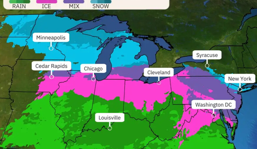
- Freezing Rain and Sleet Take Center Stage: A slick coating of freezing rain and sleet will begin to materialize across northern Missouri and Iowa before spreading eastward into the southern Great Lakes region by Wednesday evening and overnight. Cities such as Chicago, Cleveland, and Detroit will feel the brunt of this icy onslaught. Remember, even a thin glaze of ice can transform roads into skating rinks—so if you’re in the pink and purple shaded areas on the map, staying off the roads is your safest bet.
- All-Snow Zones Offer a Silver Lining: For those craving a classic snowfall rather than an icy mess, look to central and northern Minnesota extending into northern Michigan. These regions stand the best chance of seeing all-snow precipitation, offering a serene escape from the chaos of mixed wintry hazards. Still, don’t let the allure of fresh powder tempt you into underestimating Mother Nature’s might—snow-covered roads remain a challenge for travelers.
Stay tuned, stay prepared, and let’s navigate this winter wonderland together! Whether you’re marveling at the frosty scenery or bracing for its impact, safety must always come first.
Northeast Outlook: A Dynamic Winter Storm Unfolds
The Northeast is bracing for a dynamic and fast-changing winter storm that will deliver everything from icy hazards to heavy rain, with pockets of pure snowfall tucked away in select areas. Here’s what you can expect across the region:
Mid-Atlantic: A Slippery Start Before Turning Wet
In portions of the mid-Atlantic , including Baltimore, Philadelphia, and Washington, D.C. , residents should prepare for a tricky commute late Wednesday night into early Thursday morning. Freezing rain and sleet are likely to create hazardous travel conditions during this time. However, as temperatures rise later on Thursday morning, the precipitation will transition to plain rain, offering some relief—but not before the icy mix leaves its mark.
I-95 Corridor: From Snowy Beginnings to Soaking Rains
Traveling up the bustling Interstate 95 corridor from New York City to Boston , the story unfolds a bit differently. Late Wednesday night or early Thursday, snowflakes—or perhaps a messy wintry mix—will begin to fall, painting the landscape white. But don’t get too cozy with visions of a snow day; these areas will likely see a shift to rain at some point during the day on Thursday. While accumulations may be limited due to the quick changeover, even brief periods of snow or sleet could make roads slick and commutes challenging.
Interior Northeast: Ice and Snow Dominate
For those in the interior Northeast , the stakes grow higher. Significant icing is possible in central Pennsylvania , where freezing rain could coat trees, power lines, and roadways, raising concerns about power outages and treacherous travel. Meanwhile, farther north in northern New England , winter purists will find their snowy haven. This region stands the best chance of seeing all-snow precipitation, sparing it from the icy chaos affecting other parts of the Northeast. It’s here that nature’s quiet beauty shines brightest, though snow-covered roads still demand caution.
Stay Prepared, Stay Safe
As this storm sweeps through the Northeast, its ever-changing dynamics mean one thing is certain: preparation is key. Whether you’re navigating icy streets in the mid-Atlantic, dealing with a slippery start along I-95, or marveling at the serene snowfall in northern New England, remember to prioritize safety. Keep an eye on local forecasts, allow extra time for travel, and have emergency supplies ready in case winter’s unpredictability strikes.
Ice and Snow Forecast: A Dangerous Mix Grips the Region
As winter tightens its grip, a potent mix of freezing rain, sleet, and snow is set to sweep across parts of the country, creating hazardous conditions that demand attention. Here’s what you need to know about the upcoming icy onslaught.
Icy Threat Spreads from West to East
Freezing rain will carve a path of slippery danger, spreading from west to east across affected regions from Wednesday into Wednesday night and lingering into Thursday . Areas shaded in pink on the forecast map are at particular risk, with even minimal ice accumulation capable of turning roads, sidewalks, and highways into treacherous zones. As we’ve emphasized before, it doesn’t take much—just a thin glaze of ice—to make travel dangerous. If you’re in these areas, exercise extreme caution or avoid unnecessary trips altogether.
The central Appalachians , especially central Pennsylvania , face the gravest threat from this storm. Heavier icing is expected here, with accumulations potentially reaching levels severe enough to snap tree limbs and bring down power lines. This raises the alarming possibility of scattered power outages and prolonged disruptions for residents. If you live in this zone, prepare for the worst by stocking up on essentials, charging devices, and having flashlights and batteries on hand. The combination of heavy ice and gusty winds could leave some communities in the dark—and cold—for hours or even days.
This storm is shaping up to be a formidable opponent, delivering everything from slick roads to significant structural impacts. Whether you’re in the path of light icing or bracing for heavier totals, now is the time to prepare. Keep an eye on local updates, secure outdoor items that could become hazards in icy or windy conditions, and ensure your vehicle is equipped for winter driving.
Storm No. 2: Saturday-Sunday
Just as the region begins to recover from the first round of winter chaos, a second storm system is set to roll through this weekend, bringing another wave of snow and ice to many of the same areas in the Midwest and Northeast . This relentless weather pattern will once again pair low-pressure systems with lingering cold air, creating a recipe for hazardous conditions across the affected regions.
A Stripe of Snow and Ice Takes Shape
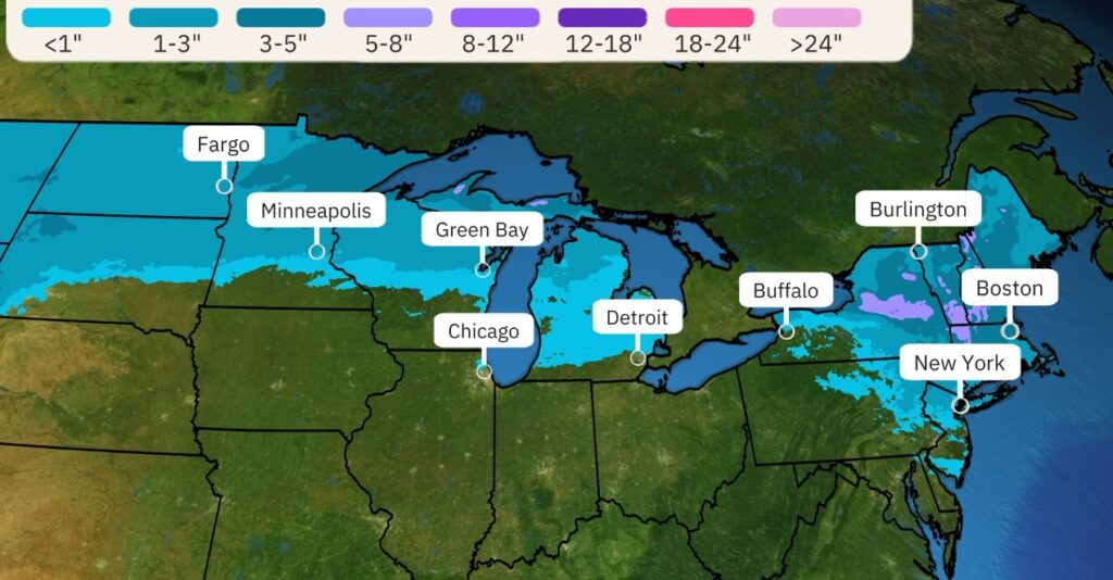
While it’s still early for precise details, forecast models suggest that by Saturday , a swath of snow and a ribbon of freezing rain or sleet will likely develop, stretching from the Northern Plains and Great Lakes to parts of the mid-Atlantic and Northeast . This setup could create yet another round of slippery roads, icy branches, and challenging travel conditions.
The storm’s progression will be quick but impactful, with the potential for accumulating snow in some areas before transitioning to mixed precipitation. As always, even small amounts of ice can make travel treacherous, so stay alert if you’re planning to venture out this weekend.
Storm No. 2: Saturday-Sunday
Just as the region begins to recover from the first round of winter chaos, a second storm system is set to roll through this weekend, bringing another wave of snow and ice to many of the same areas in the Midwest and Northeast . This relentless weather pattern will once again pair low-pressure systems with lingering cold air, creating a recipe for hazardous conditions across the affected regions.
A Stripe of Snow and Ice Takes Shape
While it’s still early for precise details, forecast models suggest that by Saturday , a swath of snow and a ribbon of freezing rain or sleet will likely develop, stretching from the Northern Plains and Great Lakes to parts of the mid-Atlantic and Northeast . This setup could create yet another round of slippery roads, icy branches, and challenging travel conditions.
The storm’s progression will be quick but impactful, with the potential for accumulating snow in some areas before transitioning to mixed precipitation. As always, even small amounts of ice can make travel treacherous, so stay alert if you’re planning to venture out this weekend.
I-95 Corridor: A Wintry Start Before Turning Messy
For those along the bustling Interstate 95 corridor , including major cities like New York City and Boston , the storm is expected to begin with a burst of snow on Saturday . However, don’t get too excited about a picturesque snowfall—this system is likely to quickly transition to a messy mix of sleet, freezing rain, and eventually plain rain as milder air moves in. While snow totals may remain modest, the initial burst of snow could still cause slick conditions before the changeover occurs.
Quick-Moving System Exits by Sunday
Thankfully, this storm won’t linger long—it’s a quick-mover , meaning most of its impacts will wrap up by Sunday . However, as it departs, any remaining snowfall will likely settle over New England , adding one final layer of winter wonder to the region before skies clear and temperatures begin to moderate.
Stay Prepared for Round Two
With two storms in quick succession, fatigue may set in, but it’s crucial to remain vigilant. The combination of snow, ice, and rain can create rapidly changing conditions, especially in areas that see repeated impacts. Keep your emergency kits stocked, stay updated on forecasts, and plan ahead for potential disruptions to travel and daily routines.